Also I am sure I picked up a book years ago in one of the local charity shops which detailed all the WW2 bombs & damage in Lewisham giving all the bombing dates and casualty numbers. It may still be at home somewhere so I will try and find it. I remember it, as there was a particulary horribly incident of a bomb landing on one of the junior schools in the area where a load of the children died.
Yes, although not in SE23 this horrible incident was probably Sandhurst Road School, SE6 which was bombed in 1943, killing 38 children and 6 members of staff. There is a mass grave for the victims in Hither Green Cemetery.
I think Sandhurst primary School was bombed deliberately in the mistaken belief that it was Sandhurst Military Academy.
All that I have read suggests the bombing was deliberate. The pilot was quoted at the time as saying that he knew what the target was. The incident also caused a lot of controversey because the anti-aircraft defences were out of action at the time.
The bombing was quite deliberate. There were Canadian troops billeted in the area around the school and military vehicles (fire engines) were parked in the school playground. This probably convinced the German Intelligence that it was actually a military target. It was the only school in London bombed during daylight. If schools were bombed during the night the children would not have been there. The Germans stated after the raid that they had bombed their target.
It is curious that the aeroplanes were able to penetrate so far inland. But I suspect that the authorities were not prepared for the unexpected.
Shake 'n vac mountain made from fibreboard eh? I suppose if it is that much of a pre-fab estate it would have been cheap and fast to just build more of the same after the war. A shame though that we're all still having to live with the architectural consequences 60 years later. In the fine city from which I hail we knocked down places like this in the 60's and 70's.
Sorry Milliebear I meant this map. Are you able to post up the left page for me?
The resolution isn't as high as it might be, so I've uploaded the relevant maps from my copy of the book. I'd previously been reluctant because I was unsure about copyright issues.
This is the link:
http://www.flickr.com/photos/stevegrindl...445257235/
There is also a key that explains the significance of the colouring and circles. Be aware, though, that downloading the images at original size might be slow.
Thanks to Hornimaniac and Steve, I was able to find my house on Steve's maps. I was told by neighbours when I moved in, that it had suffered bad bomb damage (confirmed by the purple on the map). Luckily the previous owners, two sisters, were unhurt. The house was rebuilt after the war ended with, I suspect, whatever materials was salvaged from other sites as some of the architectural features in the house were a bit incongruous...
I've been asked to upload the maps showing bomb damage towards Honor Oak Park and parts of Stanstead Road. If anybody is interested in areas I have missed, let me know and I'll see what I can do.
As a reminder, this is the link:
http://www.flickr.com/photos/stevegrindl...445257235/
These maps are great. Is there a map that shows Derby Hill / Derby Hill Crescent? If it isn't too much trouble I would love to see that.
And any of HOP Steve if you have them.
Thanks
Is there a map that shows Derby Hill / Derby Hill Crescent?
It was a little tricky as Derby Hill extends across two maps. This is the best I can manage:

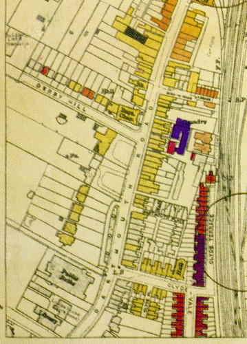
The LCC used the 1916 OS maps to mark bomb damaged buildings, updating the maps as necessary. Thus the original Derby Hill, off Dartmouth Road in the right hand image, was on the original while the 1930s extension (on the left hand map) is pencilled in. Derby Hill Crescent isn't marked at all, perhaps because there was no bomb damage there.
Have you anymore info on the bomb that fell on Camberwell Cementary? my grandfather was buried there in 1937,near one tree hill.The cementary have no info on a bomb site,but his head stone is missing with a lot of others on a plot of land now flat .
Many thanks Tim
From the map, the bomb was a V1 flying bomb. So a pretty big explosion.
I was shown a map of all the bomb damage caused during WW2 and it's seye opening. The railway line going through Lordship lane was hit as well as Forest Hill station. Plus, two V2s hit either side of Taymount Grange. It's a bizarre sight to behold... the outline of Taymount Grange with two large circles either side of it marking where bombs narrowly missed it
The area just beside Honor Oak Pk station was occupied by Wells Fireworks,then the golf course and further up Victory gardens and at One Tree Hill,a Search Light Battery held pride of place.After the school at Hither Green was bombed the plane then flew down Lessing St. and machine-gunned my mother,myself and Maureen Tulley,(we were on our way home from school,Stillness Infants) mum grabbed us and tossed us in a doorway.I was told the RAF got him 2 wks later. We lived at 286 Devonshire Rd untill a V2 flattened the area of Boveny opposite,and were then relocated to Woolstone Rd as our roof was damaged.Sometime after VE Day we moved back.The area along the railway was one of our playgrounds and was source of Slow-worms and Grass-snakes(I gave my two to the Horniman vivarium when it opened).
deov
This is a long dormant thread, but thought people might be interested to know that the London bomb damage maps (including the ones covering SE23) have been reprinted in an expensive but beautiful coffee table book having been previously very hard to get hold of -
http://www.amazon.co.uk/London-County-Co...0500518254
Just been flicking through in Daunt Books and well worth a look for anyone interested in the local history.