23-02-2008, 10:18 PM
23-02-2008, 10:21 PM
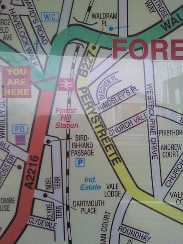
Obviously the question of location is facetious as there is a bit of a clue.
I'm guessing this is not content provided by the Ordnance Survey
I'm guessing this is not content provided by the Ordnance Survey
23-02-2008, 10:33 PM
Oh dear, where the hell did you get that from? lol
23-02-2008, 11:45 PM
it might not be as wrong as it looks. the big block of flats that runs from Vale Lodge up to near(ish) the station on Perry Vale has Perry Streete written along it (bar the odd missing letter). Could be a historical reference here?
Or, could be by the same map makers that have done that big map on the FH Central hoardings, and decided to call Bermondsey 'Bermondsy'!
Or, could be by the same map makers that have done that big map on the FH Central hoardings, and decided to call Bermondsey 'Bermondsy'!
24-02-2008, 12:23 AM
it won't be very helpful if you are looking for a post office or a wc!
24-02-2008, 12:42 AM
Ridiculous! It ceased to be Perystrete maybe two centuries ago (it was definitely Perry Vale by 1843). The block of flats that thenutfield refers to was simply the result of someone plucking a nostalgic name from an old map. This was, and still is, a sometimes absurd way of choosing names for streets and flats.
24-02-2008, 07:59 AM
Biggest joke in my mind is ( Industrial Estate ) . What industrial products are manufactured here or is just a couple of warehouses.
24-02-2008, 08:33 AM

OK, just to be clear, this is the map offered by Southern at the station (under the covered area on the platform) for the local area.
Shows how often we look at it, but I wonder what a lost visitor would make of it
24-02-2008, 09:55 AM
Fair comments and good detective work mate
Are you going to feed it back to Southern?
OK, just to be clear, this is the map offered by Southern at the station (under the covered area on the platform) for the local area.
Shows how often we look at it, but I wonder what a lost visitor would make of it
Are you going to feed it back to Southern?
robwinton wrote:
OK, just to be clear, this is the map offered by Southern at the station (under the covered area on the platform) for the local area.
Shows how often we look at it, but I wonder what a lost visitor would make of it
24-02-2008, 10:10 AM
Meet the managers http://www.southernrailway.com/main.php?page_id=92
This Thursday 28th February from 7:30am.
Please take a few minutes to stop and speak to them if you are passing through London Bridge.
This Thursday 28th February from 7:30am.
Please take a few minutes to stop and speak to them if you are passing through London Bridge.
24-02-2008, 01:48 PM
unfortunately I will not - maybe someone can do it on my behalf?
I wonder who they'll blame for this? The printers? The Council? The historians? The government? Cannot possibly be them or their shareholders!
have fun!
I wonder who they'll blame for this? The printers? The Council? The historians? The government? Cannot possibly be them or their shareholders!
have fun!
24-02-2008, 07:21 PM
That is bad... Southern should be ashamed of themselves.
25-02-2008, 10:43 AM
Deliberate errors and what you migth call 'quirks' have long been included on maps by the cartographers and publishers to prevent others copying them.
If you think that's bad, have a look at this map that a certain estate agents links to:
http://www.woosterstock.co.uk/Map.php?id...8&y=173637
This is a family site but have a look in the area around St William of York school...
If you think that's bad, have a look at this map that a certain estate agents links to:
http://www.woosterstock.co.uk/Map.php?id...8&y=173637
This is a family site but have a look in the area around St William of York school...
25-02-2008, 11:12 AM
hilltopgeneral wrote:
Deliberate errors and what you migth call 'quirks' have long been included on maps by the cartographers and publishers to prevent others copying them.
If you think that's bad, have a look at this map that a certain estate agents links to:
http://www.woosterstock.co.uk/Map.php?id...8&y=173637
This is a family site but have a look in the area around St William of York school...
If you think that's bad, have a look at this map that a certain estate agents links to:
http://www.woosterstock.co.uk/Map.php?id...8&y=173637
This is a family site but have a look in the area around St William of York school...

Oh my god! Thats shocking...
25-02-2008, 01:45 PM
Better link to ~Google Maps - they have it spelt right!
15-05-2008, 07:17 AM
I noticed the other day that thei bus stop map is totally out of date too....