While walking towards the Waldram Park Road bridge this afternoon I was surprised and delighted to see this:
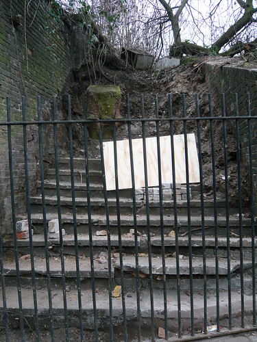
It is between the bridge and the derelict site of Bax Sash Willy's.
Workmen were repairing a crack in the bridge and had cleared this area. They had obviously taken care when removing spoil from the steps and were rather proud of what they had discovered. They told me the intended to leave it as it was.
The steps were probably built in the 1880s as a short-cut to the station.
excellent! Interesting to know
What do you think the chances are we could get it back?
Actually, I think that plot is about to be developed is it not?
Hey Steve, great discovery mate! Please can you give us a more detailed description of where this staircase is located exactly? Or do you have a photo taken from a more distant viewpoint? When I search for Box Sash Willy's I get given a postcode in Malham Road.
These steps are
on the right as you approach the railway bridge from the Devonshire Rd side, up the side of the bridge.
The area to be developed (?) with the grey hoardings is just to the right of these steps.
This extract from the 1914 OS map shows the position of the steps:
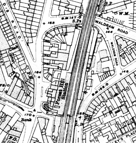
They are at the top centre, beneath "S.Ps" (I think that stands for signal posts). You can follow the route of the path to the station.
This is very interesting but not sure this would have been a public right of way but could be wrong.
Amazing what things we still find
Thanks guys! I also found the staircase on this map taken from the article about Forest Hill station:
View page...
It appears to have led to a footpath alongside the railway, and out to the front of the station, as opposed to a shortcut to the platforms inside the station.
2 questions:
1. What was the name of the public house on the corner of Perry Vale as shown on the 1914 map?
It will get my vote on any SE23 poll on pubs, and I hope it (too) is included in any future pub crawls for completeness.
2. Where was the south bound (down) station ticket office located? I always thought it was in the northern part of the current car park/maintenance area.
But the Falkor's article shows the office located next to the current staircase, a more likely place the more I think about it.
The area to be developed (?) with the grey hoardings is just to the right of these steps.
[/quote]
There are apparently going to be several (possibly 7?!) flats built there in the not too distant future- had the planning letter round ages ago as a near neighbour but can't remember the full details. I glimpsed the guys working as I passed in the car and thought they were building the steps to access the new building site!
Good find.
Railway property is strictly regulated and station entrances and exits cannot be closed without Regulatory authorisation.
So it's a great pity that it would seem from the condition of the stairs that they have not been used this side of when the station was redeveloped - otherwise we could call upon the Rail Regulator to direct Network Rail and the operator to have them re-opened.
Can anyone (still living preferably) demonstrate that they used these stairs recently ?
Been living a stone's throw from them since 1991 and never saw them uncovered, never mind used before their recent unearthing- looks like a big fat 'no' I'm afraid...
I have been living in SE 23 since 1972 and from 1949 in Sydenham and never remember any stairs.
I do recall the middle platform. Why oh why did they get rid of this.
1972?
OK, so where was the south bound (down) station ticket office located?
Or had it been demolished before then?
Thanks Will - you may well be right.
But I cant get a bearing from your picture, and your map seems to show that there are rail sidings next to the coal depot and so no platform next to this unlabelled would-be station building. This is not a station on this evidence.
On your map, the other unmarked building on the down side, is in the corner of what is now the car park. There is fairly clearly a platform next to it that leads all the way to something that looks like a staircase to the subway.
If the downside station building was there in 1875, then it was this southern most building, imo.
Steve's map (1914) above does not cover this building, but there is a platform outside a different unlabelled building by the coal depot and indeed this now looks like a station building.
2 maps. 2 potential station sites. 2 different downside stations?
Hey, in 30yrs we'll be discussing the position of forest hill pools - under which of Roz's 21st century luxury apartment blocks it was located.
I'm sure steve will be able confirm this, but I'm think the downside building was contemporary with the main station building.
there may have been an earlier station further north at the very inception of the line, but that is conjecture.
there was of course the pumping station for the atmospheric experiment which stood on this side of the tracks, so you may be thinking of buildings associated with this.
also, remember that the platforms are above the station, and the steps were, I believe, inside the building....
this[/i], from Falkor, should help;
http://forum.sydenham.org.uk/viewtopic.p...88c7489786
This is another view of the downside booking hall:

It is in front of the surviving steps down to Perry Vale and was, as Will says, built in 1883 when the main booking hall was built. It was also damaged by bombing, and demolished in 1972.
This picture shows a slightly different view. The curving curb at the entrance to the yard still survives:

Thanks Steve - there is no mistaking the location of the downside station with that first picture.
The wall and platform fencing are clearly visible.
With the original platform not reaching this site, I'd always assumed the downside station building was in the car park. I guess that car park building was just an engine shed. My bad.
Sorry for slightly diverting the thread from the path.